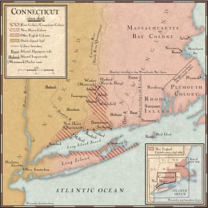
The Geology of Middlesex County

1859 Map of Middlesex County Connecitcut - small

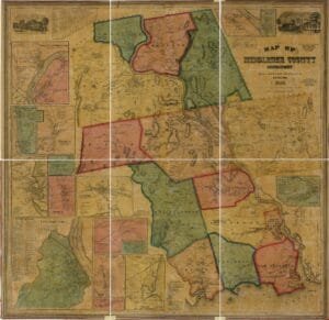
Middlesex County’s geology can be divided into two distinct regions: the highly crystalline metamorphic rocks to the east, primarily composed of gneiss and schist, and the red sandstone formations to the northwest. The metamorphic rocks are notable for their hardness and contain valuable minerals such as cobalt and nickel. The Connecticut Valley, characterized by sandstone and associated igneous trap rocks, showcases a history of sedimentation and glacial activity. The area also has post-glacial terraces that reveal significant historical flood levels, reflecting the dynamic geological processes that shaped the region.

The Original Condition of Middlesex County

1859 Map of Middlesex County Connecitcut - small

Middlesex County was established in 1785, originally comprising six towns from Hartford and New London counties, later expanding to fifteen towns, with Durham joining in 1799. The county features a varied landscape, including hills and the Connecticut River, which provides water power for mills. Historically rich in timber and fish, wildlife has significantly diminished due to human activity. The original forests, primarily oak and walnut, have mostly vanished, with only a small growth remaining. Various animals have also disappeared, leading to a dramatic change in the region’s ecology over time.

Agriculture in Middlesex County

1859 Map of Middlesex County Connecitcut - small

Middlesex County boasts fertile soil ideal for diverse agriculture, producing exceptional crops such as corn, tobacco, and fruits, particularly in towns like Clinton, Westbrook, and Middlefield. Dairy farming excels thanks to superior pastures, with the county recognized for high-quality butter. Farmers have embraced modern agricultural practices, enhancing productivity and the social status of farming families. With advancements in techniques and machinery, Middlesex County farmers are not only competitive but also play a vital role in the state’s agricultural progress, achieving notable success at state fairs and improving overall community livelihood.

Early Settlers of Middlesex County

1859 Map of Middlesex County Connecitcut - small

The early settlers of Middlesex County, primarily of English descent, began establishing towns in the mid-17th century under harsh conditions. Many were motivated by the desire for religious freedom, facing poverty and threats from Indigenous peoples. While slavery existed in the region, it was characterized by relatively humane treatment. These settlers demonstrated remarkable resilience, maintaining strict religious practices and communal bonds. They lived simply, valuing hard work, frugality, and education while fostering a culture that led to their children inheriting strength and adaptability, despite the challenging environment.

Connecticut in the Civil War

Cannon

IT IS quite unnecessary to record the events which led to the war of the great Rebellion. During the interval between the election of Abraham Lincoln to the presidency, in 1860, and the bombardment of Fort Sumter, in 1861, the position of Connecticut was not equivocal. The declaration and acts of her governor, her Legislature, and her representatives in Congress, were all in favor of a firm maintenance of the national honor, and against any concession to those who sought to compromise that honor, or to humiliate the nation. There were, however, in Connecticut, as in the other loyal States, … Read more

How Connecticut Boldly Resisted British Rule in Early America

Cannon

Connecticut played a pivotal role in resisting British rule prior to the American Revolution, notably protesting the Stamp Act and actively opposing its enforcement. The citizens organized for armed conflict after the battles of Lexington and Ticonderoga, demonstrating their commitment to liberty. During the Revolution, Connecticut troops contributed significantly in battles, while the state faced invasions, including a notable betrayal by native Arnold. In the War of 1812, Connecticut’s forces again engaged the British, most notably resisting the bombardment of Stonington. The state’s self-governance fostered a spirit of resistance throughout these conflicts.

Progress of the Colony

1654 Map of the Colony of Connecticut

In 1698, Connecticut’s General Assembly established a two-house Legislature, requiring concurrence for law enactment. The colony faced military expenses due to the war with France, issuing paper money for a Canadian expedition. By 1713, Connecticut had 17,000 residents, 38 towns, and a growing economy based on trade with New York, Boston, and the West Indies. The colony actively participated in the French and Indian Wars, significantly contributing to military efforts. Post-war, Connecticut saw rapid growth and eventually ceded lands to the U.S. while retaining some for local indemnity and education funds, laying the groundwork for future prosperity.

Connecticut’s Fight Against Tyranny

1654 Map of the Colony of Connecticut

After Charles II’s death in 1685, James II intensified the oppressive governance of the American colonies. He issued writs to revoke colonial charters, culminating in Sir Edmund Andross’s appointment as governor-general, which led to tyrannical rule in Connecticut. However, after James II fled in 1688, Connecticut’s original government was reinstated. Tensions continued with Governor Fletcher of New York in 1692, who demanded control over Connecticut’s militia. The Assembly firmly rejected his demands, asserting their rights. Legal opinions later favored Connecticut, affirming the colony’s governance and preserving its rights against external authority.

Connecticut Boundaries Established

Map of the Colony of Connecticut

In 1661, Connecticut sought a royal patent from King Charles II, leading to the 1662 charter that united it with New Haven despite local opposition to governance. By 1664, boundaries were established with the Dutch-controlled New Netherland, and later, conflicts arose when the Duke of York claimed lands conflicting with Connecticut’s rights. The tension escalated into King Philip’s War, where a brutal campaign against the Narragansetts resulted in significant casualties. This conflict highlighted the moral dilemmas of warfare and the overlooked rights of Indigenous peoples amidst colonial expansion.

Earliest Inhabitants of Connecticut

Pequot War

Before European settlement, Connecticut was home to various Indigenous tribes, notably the powerful Pequots and Mohegans. The Pequots, led by chief Sassacus, inhabited the coastal areas, while the Mohegans, under Uncas, occupied northern regions. Uncas, initially a follower of Sassacus, later allied with the English to secure his tribe’s independence. Smaller tribes also existed along the Connecticut River, contributing to a diverse Indigenous population that historians estimate to have ranged from 7,000 to 20,000, with a likely count around 16,000.